3D Laser Scanning

3D laser scanning: Unleashing the power of precision

Embrace a new era of efficiency with 3D laser scanning. Capture intricate architectural details and map vast landscapes with more accuracy.

A 3D scanner is on a tripod inside an office.

A 3D scanner used in construction.

What is 3D laser scanning?

3D laser scanning is a technology that uses laser beams to rapidly and more accurately measure distances to surfaces, creating detailed 3D representations of objects, environments, or landscapes. 

A construction worker takes survey measurements onsite with a digital scanner.

A worker takes measurements on a jobsite.

Transforming AEC: The impact of 3D laser scanning

The history of 3D laser scanning dates to the emergence of laser technology in the 1960s. Across decades, it evolved from early laser range finders to the introduction of LIDAR systems in the 1980s for aerial mapping. In the 1990s, terrestrial laser scanning gained momentum, allowing ground-based 3D scanning. The 2000s saw the integration of laser scanning with GPS and IMUs for georeferencing, leading to widespread adoption in various industries during the 2010s. Ongoing advancements in miniaturization and cost reduction have made 3D laser scanning more accessible and continue to expand its applications in fields such as construction, manufacturing, and cultural heritage preservation.

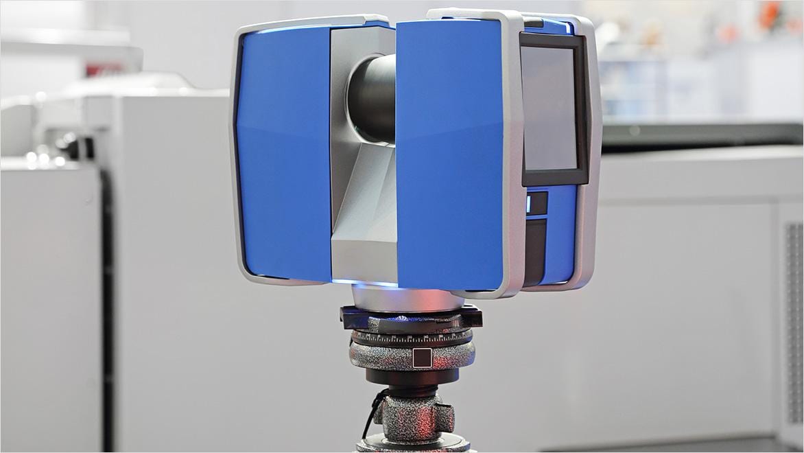
A 3D laser scan emits laser beams toward a target object or surface and measures the time it takes for the laser pulses to bounce back. These time measurements, combined with angular information, enable the scanner to calculate a highly precise distance and orientation of each point on the object’s surface. Multiple laser beams are rapidly emitted from various angles to capture a dense set of 3D coordinates, creating a point-cloud representation of the object. 

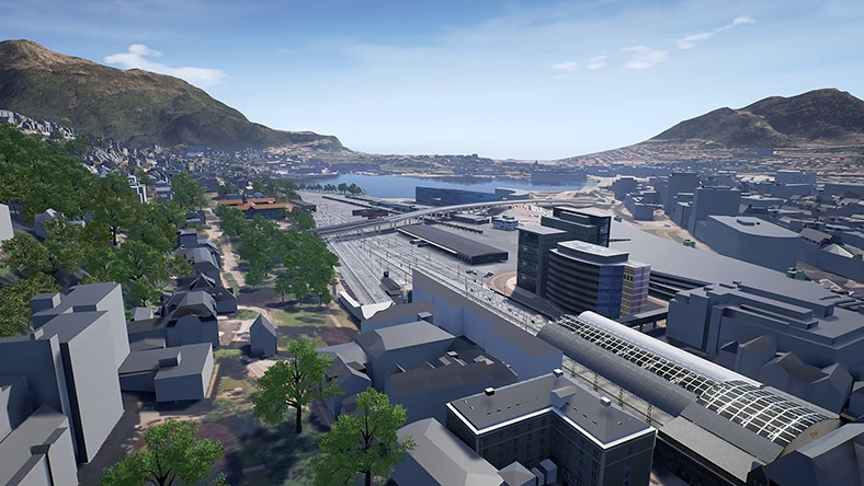
A 3D laser scan of a building can yield valuable deliverables, including raw point-cloud data, 3D meshes or models, floor plans, elevations, sections, and profiles. These are essential for architectural and engineering design, space planning, as-built documentation, clash detection, facility management, and historical preservation. They provide a highly accurate and detailed representation of the building’s geometry and condition, which helps stakeholders make informed decisions for renovations, construction projects, facility management, and more. The specific deliverables produced depend on the project’s objectives and requirements.

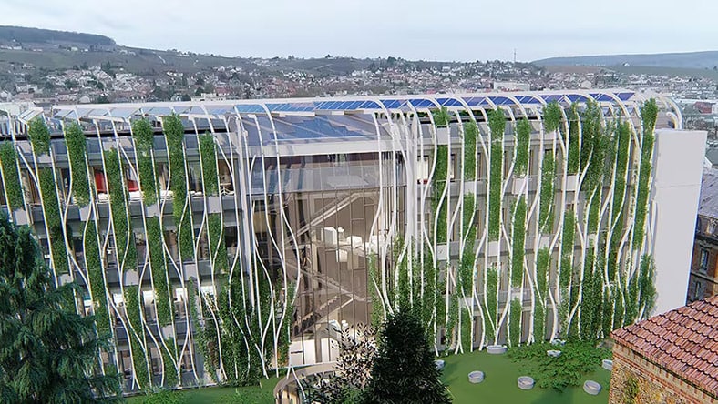
3D laser scanning and building information modeling (BIM) work together seamlessly to improve building-related projects. Laser scanning captures detailed as-built data in the form of a point cloud, which is integrated into BIM software. BIM software converts this point cloud into a 3D BIM model that represents the existing building’s conditions. This model can be aligned with the design phase to help ensure new elements fit more accurately within the existing structure, and it enables clash detection to identify conflicts between the design and as-built conditions. The integrated BIM model enhances visualization, analysis, and documentation, making it a valuable tool for construction, renovation, and facility management—ultimately improving project accuracy and efficiency.

Benefits of 3D laser scanning

3D laser scanning has become an indispensable tool across many industries due to its ability to capture highly detailed and more accurate 3D data. Here are some of the key benefits of 3D laser scanning:

High accuracy

Laser scanning provides extremely accurate measurements, making it effective for applications where precision is critical, such as engineering, construction, and product manufacturing.


Rapid data capture

Laser scanners can quickly collect a large amount of data, reducing the risk associated with scanning high buildings and improving field staff safety.


Noncontact technology

Laser scanning is noninvasive and doesn’t require physical contact with the object or environment being scanned, making it ideal for fragile, hazardous, or hard-to-reach locations.


Comprehensive documentation

Laser scanning creates detailed and comprehensive digital records of objects, buildings, or landscapes, which are invaluable for preservation and historical archiving.


Visualization

Data from 3D laser scans can be used to create highly realistic visualizations, aiding in the design, analysis, and communication of complex structures and spaces.


Clash detection

When integrated with building information modeling (BIM), laser scanning helps identify clashes between design plans and existing structures, reducing costly construction errors.


Autodesk software for 3D laser scanning

Plan, design, construct, and manage buildings with powerful tools for Building Information Modeling.


Reality capture and 3D scanning software and services


Cloud-based design co-authoring, collaboration, and coordination software for architecture, engineering, and construction teams. “Pro” enables anytime, anywhere collaboration in Revit, Civil 3D, and AutoCAD Plant 3D.


Customers using 3D laser scans

An archaeologist unearths a skeleton in dirt.

AfricanFossils.org

Discovering new clues about the past

Famed paleontologist uses 3D laser scanning and Autodesk ReCap to bring ancient fossils to light.


Rendering of Bergen Station, the terminus of Norway's Bergen Line.

Norconsult

The gamified future of infrastructure design

Infrastructure pacesetters detect potential design problems and prevent construction delays with ReCap.


Image courtesy of Norconsult AS/Bane NOR/Baezeni

A biophilic building design features lush vegetation on the exterior.

OUYOUT

Scan to BIM for sustainable construction

French architecture firm creates a "living, breathing," sustainable building with Autodesk Revit and ReCap Pro.


Image courtesy of OUYOUT Architects

3D laser scanning resources

Learn how 3D laser scanning optimizes each phase of a construction project’s lifecycle.


See how digital tools helped a construction and engineering contractor revitalize Hong Kong’s construction industry.


Learn the basics, benefits, and implementation strategies of 3D laser scanning in construction.


Frequently asked questions (FAQ) about 3D laser scanning

Is 3D laser scanning the same as LIDAR?

Although 3D laser scanning and LIDAR both use laser technology for distance measurement and 3D data capture, they serve different purposes and have distinct characteristics. 3D laser scanning is a versatile method for highly precise and detailed 3D data capture in localized environments, commonly applied in fields such as architecture, engineering, and manufacturing. In contrast, LIDAR, short for light detection and ranging, is a specific remote-sensing technology designed for large-scale mapping, often used to create elevation models and terrain maps for applications such as environmental monitoring, forestry management, and autonomous vehicles. 

How accurate is a 3D laser scanner?

The accuracy of a 3D laser scanner varies depending on factors such as the scanner type, specifications, environmental conditions, calibration, scanning technique, and operator skill. In general, 3D laser scanners are known for their high accuracy, often achieving submillimeter to millimeter-level precision under optimal conditions. However, real-world factors, including the type of surfaces being scanned and the quality of data processing, can introduce variations in accuracy. Accurate results rely on proper calibration, careful scanning methodology, and skilled operators, along with factors such as distance to the object and the use of reference points. 

Can you 3D scan a building?

3D scanning buildings uses laser-scanning technology to capture detailed and accurate representations of the interior and exterior of a structure. This process entails positioning a 3D laser scanner at various locations within and outside the building, emitting laser beams to measure distances and creating a dense point cloud of 3D coordinates. Multiple scans are typically required to cover the entire building. After data acquisition, the scans are registered, aligned, and processed to create a seamless 3D representation of the building. This technology is widely used in architecture, construction, historical preservation, and facility management.