Bird Paradise in Singapore puts nature first with advanced design

See how Obayashi built a complex Bird Paradise in Singapore using a “nature-first” approach and advanced tech like BIM and digital twins.


Image courtesy of Obayashi Corporation.

Bird Paradise Singapore under construction aerial view

Yasuo Matsunaka

May 1, 2024

min read
  • The Mandai Wildlife Reserve is home to Singapore’s wildlife parks, including the 42-acre Bird Paradise.

  • Obayashi Singapore Pte Ltd built this complex facility using an integrated building information model (BIM), a digital twin, drones, and 3D scanners to streamline processes and increase sustainability.

  • Creating a balance between conservation and design—including constructing a mesh-covered aviary as tall as an eight-story building—required extensive digital coordination.

Mandai Wildlife Group is the steward of the Mandai Wildlife Reserve, a destination home to the Singapore Zoo, Night Safari, River Wonders, and the latest park, Bird Paradise, in northern Singapore. Key highlights of the 42-acre Bird Paradise include large walk-through aviaries that reflect different habitats of the world, housing bird species like the roseate spoonbills, scarlet ibises, American flamingoes, and milky storks.

Located adjacent to a nature reserve, the development of Bird Paradise has to take into consideration the surrounding environment, while constructing the large, complex structure. It was also a priority to integrate organic design elements while maintaining the original natural topography as much as possible.

Bird Paradise Singapore staff person interacting with macaws and other parrots
Bird Paradise includes habitats for macaws and other parrots. Image courtesy of Obayashi Corporation.

Obayashi Singapore Pte Ltd, a wholly owned subsidiary of Obayashi Corporation, one of five major Japanese construction companies, built Bird Paradise using advanced digital technology to improve stakeholder collaboration and meet the high sustainability demands. Shusaku Kawamoto, general manager of Obayashi Corporation’s Digital Transformation Division and innovation lead of the Asia Digital Lab in Singapore, says, “We have achieved an SSOT [single source of truth] among numerous stakeholders in this large and complex project and operated a digital twin based on that SSOT.”

An integrated BIM managed the design and development, coordinated construction sequencing, and aided in site inspections. Minimizing environmental impacts also required verifying and addressing constructability through a virtual design and construction process.

From digital modeling of nature to digital twin

Bird Paradise Singapore rice paddies landscaping
Drone mapping helped optimize excavation and minimize soil disposal, allowing for the creation of terraced rice paddies and other beautiful landscape features. Image courtesy of Obayashi Corporation.

Patrick Chia, Obayashi Singapore’s project director for Bird Paradise, says that to overcome challenges during the virtual design and construction phase, teams used Autodesk Revit and Autodesk Navisworks. “The real challenge was to ensure consistency between the real and digital worlds. That could only be achieved with the cooperation of everyone involved in the project. This allowed the digital data to become the SSOT among the stakeholders so that we could take full advantage of the digital twin.”

To create a digital file that accurately replicated the vast, rugged terrain, reality capture was first conducted using drones and 3D scanners. The collected data was processed in Revit, and Autodesk ReCap Pro was used to generate outputs including point clouds, orthomosaic images, toposurface models, and 3D contour lines, for use in subsequent tasks.

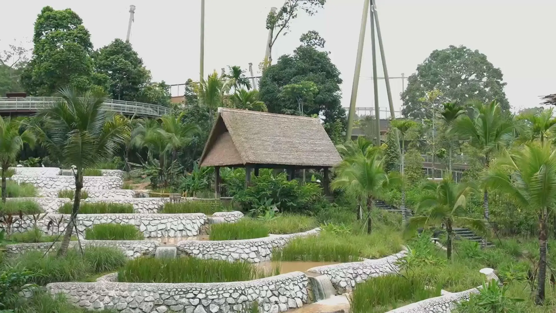
“Instead of using traditional land-surveying methods, we used a drone to map the entire site and generate a comprehensive ground surface model,” says Paul Andaya, BIM manager for the Bird Paradise Project. “This allowed us to analyze the level differences between the current state and the proposed levels using Revit and Dynamo. We were able to optimize the movement of soil from the excavation area to the backfill area, minimizing both excavation and soil disposal. One of the outcomes was the beautiful terrace rice field landscape.”

To maximize the preservation of bird habitat, considering the natural environment and sustainability were paramount in the construction phase. “We took an additional step by superimposing site utilization drawings onto orthomosaic images generated from drone mapping to closely monitor site execution and ensure it’s been maintained in its natural state,” Andaya says. “Without a digital twin, overseeing the environmental impact of each construction phase on nature would be challenging.

“The combination of point clouds and the integrated BIM in Navisworks gave us a complete visualization of the project and allowed us to efficiently identify critical issues and resolve them before construction,” Andaya says. For instance, the design, originally presented as a clay model, was converted to a 3D surface mesh using a 3D laser scanner and optimized for seamless integration with BIM to form the basis of a digital twin.

“This became a valuable tool for the client, consultants, and subcontractors in evaluating the accuracy of the design, smooth coordination, creation of detailed and schematic drawings, and accurate quantity pickup,” Andaya says.

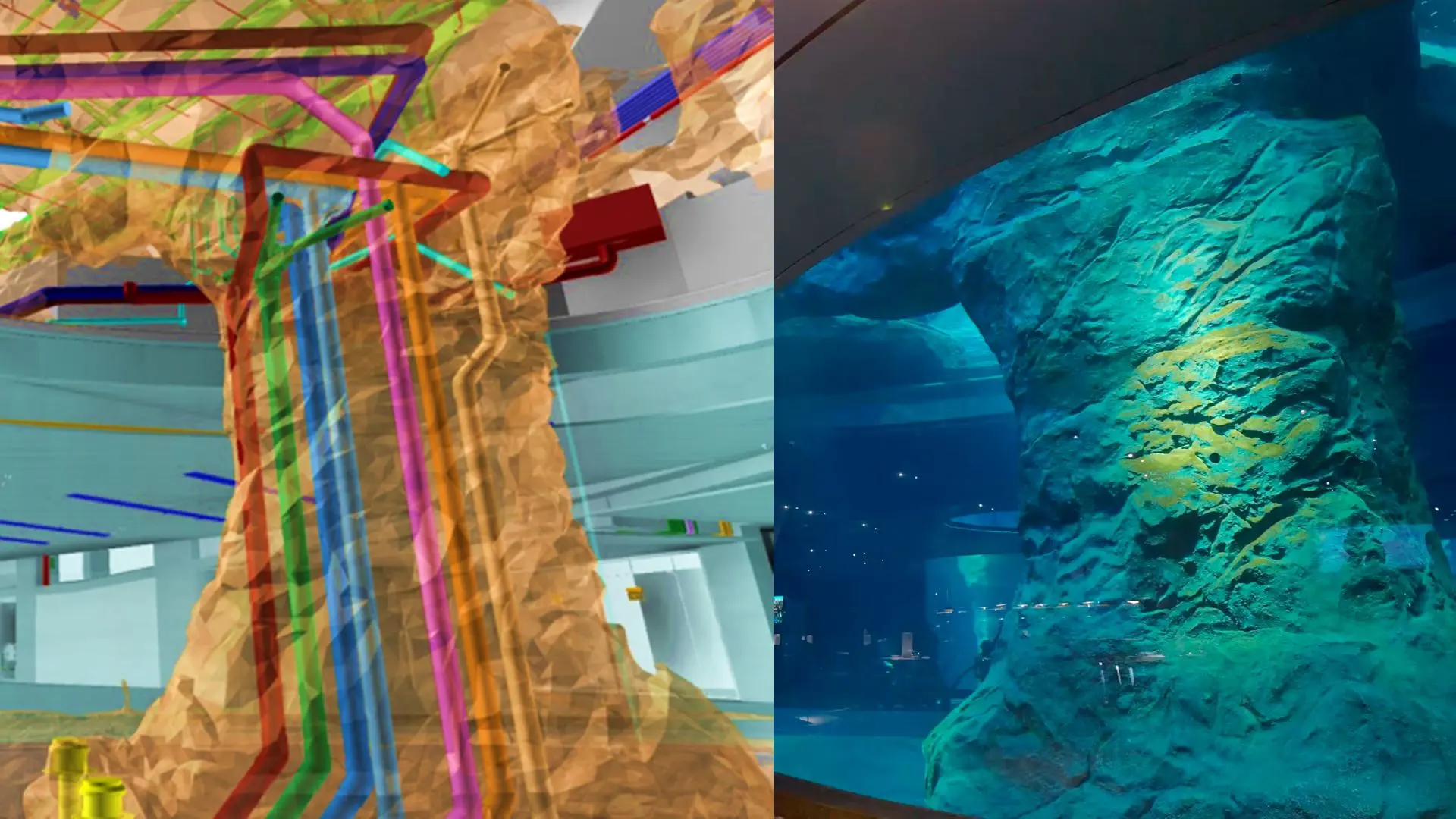
In addition, when fitting structural supports and mechanical, electrical, and plumbing (MEP) systems inside complex rockwork to be submerged in acrylic tanks, the company used laser scanning, Autodesk 3ds Max, and Navisworks to resolve interferences. The digital twin functioned as an SSOT for drawing and manufacturing in all areas, with excellent results.

Best practices using digital twins

Bird Paradise Singapore digital twin showing MEP systems for underwater rockwork structures
The digital twin helped the design and construction teams safely fit supports and MEP systems within complex rockwork structures. Image courtesy of Obayashi Corporation.

The digital twin was used to solve design problems and facilitate construction in the field. The vision of a complex walkthrough bird aviary was realized as a space covered with a huge mesh that allows birds to fly freely. Its load is supported by steel columns the height of an eight-story building.

Coordinating the design and installation of the sloping columns and foundations was extremely complex and required positioning and orientation along multiple axes. After problems were detected and the structure was adjusted in virtual space through Navisworks, construction drawings were generated from SSOT data. Integrating BIM with engineering methods improved the accuracy of collaboration and ensured the project met specifications. Penguin Cove, an immersive experience that re-creates an underwater kelp forest and rocky beaches, used 23 massive panels weighing up to 10 tons each. Mirroring every detail of the structure with the digital twin ensured efficiency, safety, and optimal use of resources.

The digital twin was also used as an SSOT for on-site inspections, with optical and laser scanning devices accurately comparing the results with the digital twin to ensure that quality standards were met.

“Our true goal was for all stakeholders to work together toward a common goal and achieve it,” Andaya says. “With tremendous effort on the part of all parties involved, the digital twin was a reliable foundation we could return to the concept of coexistence. This is the ultimate form of a ‘single source of truth.’”

Yasuo Matsunaka

About Yasuo Matsunaka

Yasuo Matsunaka is a keyboard player, space-movie devotee, editor of Design & Make with Autodesk Japan, and international content manager for APAC and Japan at Autodesk.

Recommended for you